

Northern Rivers Rail Trail
South Murwillumbah
The Northern Rivers Rail Trail is a recreation and nature trail winding through some of...
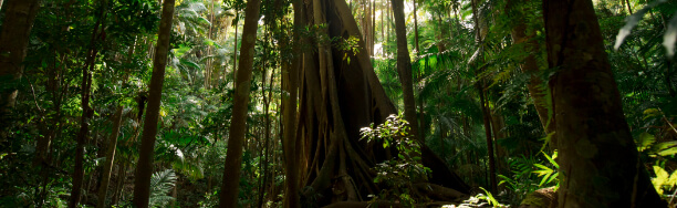
Wollumbin, which rises from World Heritage-listed Wollumbin National Park to a height of 1,157 metres above sea level, is a remnant central vent of an ancient volcano. Formerly known as Mount Warning, this spectacular peak can be viewed from a range of vantage points in the surrounding massive crater (caldera), including Cudgen Nature Reserve, Border Ranges National Park and Nightcap National Park, Cape Byron Lighthouse and various settlements. Its highly significant to Aboriginal people, particularly the Bundjalung nation, as a place of sacred ceremonies linked to traditional law and custom.
Wollumbin National Park is great for family visits. Head off on the Lyrebird track for a short walk through the lush rainforest, then make your way to Korrumbyn Creek or Breakfast Creek picnic areas for lunch.
Wollumbin (Mount Warning) Summit track and Aboriginal Place will remain closed. Decisions about the future of the summit track will be made by Aboriginal custodians, represented by the Wollumbin Consultative Group (WCG), which represents a range of Aboriginal groups and families, including men and women with a connection to the site.
Wollumbin is highly significant to Aboriginal people, particularly the Bundjalung nation. Visitors are asked to respect their wishes and not climb the summit track.
South Murwillumbah
Burringbar
Burringbar
Tweed Heads
We wish to acknowledge the Ngandowal and Minyungbal speaking people of the Bundjalung Country, in particular the Goodjinburra, Tul-gi-gin and Moorung – Moobah clans, as being the traditional owners and custodians of the land and waters within the Tweed Shire boundaries. We also acknowledge and respect the Tweed Aboriginal community’s right to speak for its Country and to care for its traditional Country in accordance with its lores, customs and traditions.


